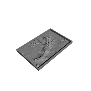
Hawaiian Islands with seafloor


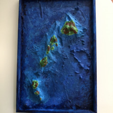


Hawaiian Islands with seafloor
Published 2017-01-16T10:52:42+00:00
The above sea level height-data for this model is taken from the Space Shuttle Radar Topography Mission dataset (http://dwtkns.com/srtm/) and the seafloor is from the NOAA's ETOPO1 dataset (http://maps.ngdc.noaa.gov/viewers/wcs-client/).
After combining the two heightmaps I displaced the terrain onto a high-resolution plane and added surrounding walls exactly in line with the sea level. Once the sea-floor was painted, I poured liquid resin onto the model up to the walls. After the resin had set I painted the islands. The model is painted with acrylics and inks.
Printing
The pictured model was printed at 0.2mm layers, with 3 bottom and 4 top layers to ensure a smooth sea floor.
Resin fill
Using any hard-setting liquid resin, fill the model up to the sea level (the side walls are in-line with the sea level) to create a transparent ocean.


| Date published | 16/01/2017 |
| Technologie | FDM |
| Support Free | YES |

Thanks man! It ended up really nice and my mom was very happy about it! Nice work